RESEARCH TITLE Research and Development Regarding the Construction of an Evacuation Guidance Support Platform Based on AI and IoT Sensing for Disasters such as Torrential Rain Flooding, Fires, and Earthquakes
RESEARCH
RESEARCHERS
Principal Rsearcher
Department of Network Design
Guest Professor Kazuyoshi Oshima

Member
Department of Media Science
Professor Mutsuo Sano
Member
Department of Network Design
Professor Katsutoshi Tsukamoto
Member
Department of Information and Computer Science
Professor Atsuo Ozaki
Member
Department of Data Science
Associate Professor Hideo Araki
Member
Department of Architecture
Professor Toshiya Okayama
Member
Department of Architecture
Associate Professor Ryohei Kono

Member
Department of Civil Engineering and Urban Design
Professor Kohji Tanaka

Member
Department of Civil Engineering and Urban Design
Professor Yukikazu Yamaguchi
OVERVIEW
We conduct research and development into the construction of an evacuation guidance support platform for regions expected to be subject to flooding, fire, and earthquake damage, via AI for predicting localized torrential rain, evaluations on the danger level of building destruction and road blockages, data collection/integration analysis via IoT sensing for river and manhole water flow/water quantity, and danger level detection of buildings and roads, in order to counter the heavy damage caused to regions by torrential rain flooding, fires, and earthquakes, etc.
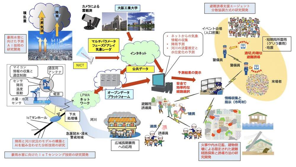
At the Faculty of Information Science and Technology and Faculty of Engineering Departments A and C at the Osaka Institute of Technology, we collaborate with municipalities in Hirakata City, Osaka Prefecture, and Kyoto Prefecture, as well as the National Institute of Information and Communications Technology (NICT) to conduct research and development into the construction of a disaster evacuation guidance support platform, via the following six categories. We promote research and development in the six categories of (1) Research on distributed cooperative agents for supporting evacuation guidance, (2) Research on basic AI technologies for predicting localized short-term torrential rain (sudden squalls) utilizing phased array radars and cloud image data, (3) Data assimilation analysis using the collection of IoT sensing data from sewer manholes and correlation between that data and the flow of sewage pipes, (4) Estimation technology for regions in danger of flooding utilizing data on small and medium-sized rivers in Hirakata City and Osaka Prefecture, (5) System design for disaster preventive urban planning that uses multi-agent technologies, etc., and (6) Research on evacuation guidance and fireproofing/rescue activity guidance systems utilizing danger prediction and sensing technologies, and the construction of an disaster evacuation guidance support platform that integrates all of the above.
The integrated analysis of this prediction data and IoT sensing data as big data will enable the construction of an efficient and effective disaster evacuation guidance support platform and system design for disaster preventive urban planning to tackle torrential rain flooding, fire, and earthquake damage, and this will enable us to greatly contribute to optimal evacuation guidance support in real-time by utilizing building/road sensing data, danger level judgment in times of fire or earthquake, support for making decisions on optimal evacuation routes and priority regions for resident evacuation guidance in the event of prolonged rain, and support for the emergency evacuation guidance of large numbers of visitors to regional event venues.
Achieving the themes of this research and development will enable the results to be rolled out to other regions and contribute to the development of safe and secure regional societies utilizing IoT, BD, and AI technologies.
BASIS OF RESEARCH
By promoting concurrent research into six categories of elemental technologies, we will construct an overall system for integrating the results of each category from the second year, and in the third year, we plan to collaborate with regional municipalities to perform integrated analysis on prediction data and sending data and conduct empirical studies on utilizing the evacuation guidance support platform.
The specific six categories are:
- Research on distributed cooperative agents for supporting evacuation guidance
- Research on predictive AI system for torrential rain
- Research on IoT sensing for torrential rain flooding
- Research on urban flooding prediction system for torrential rain
- System design for disaster preventive urban planning that uses multi-agent technologies, etc.
- Research on evacuation guidance and fireproofing/rescue activity guidance systems utilizing danger prediction and sensing technologies
The issues to solve, environmental analysis, social meaning, future potential, and technological features of each category are indicated below.
1. Research on distributed cooperative agents for supporting evacuation guidance
Because earthquakes and localized short-term torrential rain (sudden squalls) accompanied by sudden changes in the weather occur in unexpected situations, many people face such disasters while they are going about their day-to-day lives. These natural disasters cause the largest human damage at major stations with a high population density, large shopping malls, and large-scale event venues. This research aims to develop a method for providing visitors at crowded event venues with safe and quick evacuation routes via multiple evacuation guides or security guards, based on information on the distribution and flow of people obtained from multiple sensors installed at event venues and the various types of sensing information indicated below.
We aim to develop a new method for providing evacuation guides or security guards with appropriate evacuation guidance instructions and evacuation routes in real-time, based on the constantly changing situation in dangerous areas and information on crowd distribution at events by adopting multi-agent simulation technology and various optimization technologies. For example, with sudden torrential rain we will also investigate a mechanism for requesting improved observation accuracy on the weather and flooding at specified areas to the sensors, eg. weather radars and so on, in order to improve the precision of the provided information.
In Hirakata, the city where the Faculty of Information Science and Technology of the Osaka Institute of Technology is located, an event called “Hirakatashuku Kurawanka Gorokuichi” that attracts around 10,000 citizens is held in the city center each month, which has the need for evacuation guidance in the event of sudden torrential rain or an earthquake, and we have started collaborating with Hirakata and the event organizers.
If we can achieve such a system, not only will it be able to be used as the basis for various disaster prevention measures, but it may become social infrastructure that supports the safety and security of visitors and the effective management of event/facility operators both at normal times and in times of emergency, such as businesses that utilize human flow information.
2. Research on predictive AI system for torrential rain
One issue facing an AI system for torrential rain is that it is necessary to forecast the location and time of the downpour at least 30 minutes in advance, in order to provide evacuation guidance and implement countermeasures for flood damage, as sudden torrential rain has the ability to exceed rainfall of 50 mm/h in an interval as short as 5 or 10 minutes.
In order to solve this difficult problem, the Disaster Prevention Research Institute at Kyoto University is researching how the signs of localized short-term torrential rain can be understood by utilizing the rainfall distribution data (XRAIN) observed by the weather radar network maintained by the Ministry of Land, Infrastructure, Transport and Tourism, and there are examples of some functions being used in XRAIN trial systems, but they are yet to be released to the public. This new initiative utilizes cloud data captured via optical cameras installed in regional areas in addition to XRAIN data and the open data of Phased Array Weather Radar (PAWR) researched at NICT to aim to achieve a highly accurate prediction system, and there are no previous examples of research that combines actual cloud image analysis with XRAIN and PAWR data.
At the Faculty of Information Science and Technology of the Osaka Institute of Technology, we have constructed a system for automatically capturing images of the clouds in the sky above the neighboring area every minute and accumulating those images on a data server from July 2019, and are constructing a database that focuses on localized short-term torrential rain during the day time. We are also creating a database that combines this data with XRAIN data from the same time, comparing localized short-term torrential rain that occurred in the region around Hirakata 2019 with cloud image data and the open data of XRAIN and PAWR, and utilizing an AI platform to learn the relationship between the three types of data, in order to build a method for analyzing and forecasting the passage of time over the 30 minutes before the torrential rain occurs. We have also received approval on collaborating with NICT, which holds undisclosed PAWR data, and this year we will work on ideas for algorithms to effectively utilize the various data to achieve a highly accurate torrential rain prediction method using AI.
If we can achieve this method, it will be able to be utilized in regional disaster prevention measures such as evacuation guidance support based on torrential rain forecasting, and will be highly meaningful for society in the construction of safe and secure social infrastructure.
3. Research on IoT sensing for torrential rain flooding
The challenge is to develop a system that obtains data on water levels, etc. in regional sewer systems via various sensors located in several sewer manholes, and forwards that data to an agent server installed at a site via LPWA. Another challenge is to develop a protocol for switching between a real-time measurement mode that can respond to agent instructions when the evacuation guidance support agent is running and an intermittent operation mode for regular times, as the system needs to run off a stable battery supply over long periods of time in manholes without a mains power supply. In order to solve this problem, we are investigating a regional water flow danger level prediction method that utilizes the water level and water flow data from various sensors installed in sewers and river tributaries in the region.
Deterioration in the sewers operated by local municipalities is leading to problems with earthquake resistance and increasing and decreasing water flow due to unknown causes. In particular, when short-term localized torrential rain occurs, the sudden increase in rainwater can mix with sewage, despite the adoption of a system for dividing sewage from rainwater. Problems can occur if the capacity of the sewage treatment plant is exceeded, and can lead to rapid flooding or inundation without effective countermeasures being implemented. Such sudden flooding causes great difficulties to the life of citizens because of the lack of swift evacuation guidance and actions.
In this category, we will link with local municipalities to install water flow and water level sensors inside the manholes of the sewage system, in cooperation with the local waterworks department, and install other sensors to measure the rainfall, temperature, and vibrations in the area around the manhole. The measurement values collected from these sensors are forwarded from the wireless equipment installed in the manholes to the evacuation guidance support agent via an LPWA network. This is the type of IoT sensing system that we will develop to tackle torrential rain flooding.
Although past attempts have been made to install sensors in manholes to measure the water level and water flow, there are no examples of networking the sensors over a region and utilizing them to predict flooding.
If we are able to achieve this system, we should be able to improve the precision of predicting the urban flooding including that of rivers, which is indicated in the next category, and our evacuation guidance support system will be able to greatly contribute to the construction of regional social infrastructure that is safe and secure.
4. Research on urban flooding prediction system for torrential rain
Based on the correlation between the data obtained from the sensors installed in manholes as indicated in category 3 and the flow of sewage pipes, we will implement a hydrodynamic approach that utilizes a data assimilation method for the faster prediction of flooding in urban areas.
After developing the elemental technologies indicated in each category, we plan to build a system prototype for social implementation, which implements the data assimilation method and sensor observations.
Based on tests in a demonstration system, we will contribute to avoiding the paralysis of urban functions via various measures for reducing flood damage, including the construction of safe and secure social infrastructure with our evacuation guidance support system.
5. Institutional design for disaster preventive planning that uses multi-agent technologies, etc.
We are conducting integrated research to improve urban planning systems by incorporating the results of evacuation route optimization for large-scale damage caused by tsunamis or flooding in underground shopping centers in Osaka, based on the data obtained from the fundamental technologies in categories 1. and 3.
More specifically, this involves the examination of sensor technologies for the real-time detection of customer behavior in underground shopping centers. At the same time, we will organize information on the ability of underground shopping centers to attract customers and evacuation areas/routes in GIS to propose optimal methods for sensor installation, and plan to build a prototype for new underground shopping center management systems toward the goal of social implementation.
Clarifying the necessity of the fundamental data required for institutional design and the form of the system that will be based on that data will not only contribute to the construction of BCP for companies that operate underground shopping centers, but also contribute to saving the lives of many in the event of an emergency.
6. Research on evacuation guidance and fire prevention /rescue activity guidance systems utilizing danger prediction and sensing technologies
The regional disaster prevention planning conducted by local municipalities judges the level of danger facing urban areas and estimates damage that could occur, and public facilities and disaster prevention zones are organized based on that information.
However, many such plans are based on rough and uncertain assumptions. It is difficult to predict disasters perfectly, and they may not occur as expected. When an unexpected disaster occurs, disaster prevention measures based on rough and uncertain assumptions will not function.
That is why we need optimal solutions for evacuation routes, based on the current appraisals of urban area danger levels.
Existing appraisals of danger levels do not take into account the reduced sight distance due to the spreading of smoke caused by fire and the adverse effect it can have on evacuations, so we will analyze this situation via a numeric analysis.
Then, we will build sensing systems in urban areas with a high level of danger, and build a system for safer disaster prevention activities, which enables the selection of alternate routes based on real-time information on road blockages during an evacuation, etc.
In such analysis and system construction, our research is original.
Virtual reality disaster experiences and technologies supporting disaster prevention awareness building via evacuation simulations are in high demand by local municipalities, schools, and companies. In addition to our past initiatives, we will also focus on enhancing systematic awareness building for disaster prevention.
These results will lead not only to evacuations in the event of a disaster but also speed up rescue operations and firefighting operations via the reverse route from evacuation. This research will also have social meaning and future potential in regard to these points.
EXPECTED EFFECT
Expected Results of Research
- Publishing our research on a cooperative multi-agent simulation system for evacuation guidance (the Institute of Electronics, Information and Communication Engineers, etc.)
- Publishing our research at international conferences and submitting papers to the Institute of Electronics, Information and Communication Engineers or the Information Processing Society of Japan
- Publishing our research regarding predictive AI for localized short-term torrential rain (Institute of Electronics, Information and Communication Engineers or Information Processing Society of Japan)
- Publishing our research at international conferences and submitting papers to the Institute of Electronics, Information and Communication Engineers or the Information Processing Society of Japan
- Publishing our research on IoT sensing for torrential rain flooding
- Publishing our research at international conferences and submitting papers to the Institute of Electronics, Information and Communication Engineers
- Submitting Papers to the Japan Society of Civil Engineers and International Conferences
- We will submit to journals that are recorded to the SCOPUS database, such as that of the Architectural Institute of Japan and the City Planning Institute of Japan
Expected Results of Intellectual Property
We will apply for two patents regarding a cooperative multi-agent simulation system for evacuation guidance or predictive AI for localized short-term torrential rain.
CONTACT US
For any inquiry about this project, please contact Center for Research Administration & Social Outreach.